|
Population and Settlement:
Present day Lebanon was known as Phoenicia during it’s earliest settlements. Phoenicia was located in the Fertile Crescent. The location of Phoenicia was in the western region of the Fertile Crescent. Moreover, Phoenicia was near the Mediterranean Sea and that was a strong resource for that area. Phoenicia was made up of settlements referred to as city-states. Some of the important cities in Phoenicia were Tripoli, Byblos, Sidon, Arwad, Baalbek, and Tyre. In 3200 BCE, was when the Phoenician city-states started to take form (Mark). Like Jared Diamond emphasizes in Guns, Germs, and Steel it is the geography, the land that determines the success and growth in a civilization. With that being said, that is why the Phoenician’s settled in the Fertile Crescent because it had a plentiful amount of plants and animals there to survive off of. The Mediterranean climate of the Fertile Crescent was also an asset to the success of civilizations there with the wet winters and dry summers. Consequently, the Fertile Crescent focused on the domestication of plants and animals. Wheat, barley, corn, beans, goats, sheep, cows, pigs, etc are just a few of the plants and animals that blessed the Fertile Crescent. In addition, when looking at the geography of Lebanon and Phoenicia there are two mountain ranges. The mountain ranges cause the civilizations to turn towards the sea for civilization which is the western region of the Fertile Crescent. With that being said, the major city-states in Phoenicia were all coastal cities on the seashore. Like what Jared Diamond discusses in Guns, Germs, and Steel when civilizations are able to domesticate crops and animals and have a steady reliable source of food the civilization can then step away from farming and start to specialize in other areas of work. In regards to Phoenicia, it was shipbuilding and a rise in sea trade that flourished there between 1500-322 BCE (Holst). Also mentioned in Guns, Germs, and Steel, even though the Fertile Crescent has some of the most nutritious crops it had to be abandoned because it could not sustain non-stop, intense farming. It was lacking a water supply which is essential. That piece of knowledge justifies why the most of the population and the Phoenician city-states lived on the coastal plain because there was the sea there that supplied water. Coastal cities all over traded with Phoenicia and because of that it is said that the Phoenician alphabet was created to keep track of the sea trades taking place. Therefore, in 1100 BCE the Phoenicians developed an alphabet and system to document (Mark). Alexander the Great conquered Baalbek in 334 BCE. Not to long after, Byblos and Sidon were conquered in 332 BCE. It was not until the fall of Tyre that caused all the other city-states to surrender to Alexander’s rule which ended the Phoenician Civilization and made way for the Hellenistic Age (Mark). Crusades, Roman conquering, British rule and more have influenced the land that is now known as Lebanon. The Lebanese people ethnically, are a mixture of Greek, Phoenician, Armenian and Arab elements. Arabic is the official language spoken in Lebanon. Sources: Diamond, J. (1998). Guns, germs, and steel: The fates of human societies. New York: W.W. Norton &. Holst, S. (n.d.). Phoenicians Ancient Ships & Sea Trade. Retrieved September 17, 2015. Lebanon Geography. (n.d.). Retrieved September 19, 2015, from http://www.israel-a-history-of.com/map-of-lebanon.html#gallery%5BpageGallery%5D/1/ Mark, J. (2009). Phoenicia. In Ancient History Encyclopedia. Phoenician Tade Routes. (n.d.). Retrieved September 19, 2015, from http://nephicode.blogspot.com/2010_11_01_archive.html Additional Information: #1-This source acts as a Phoenician Encyclopedia. Furthermore, this source is beneficial when trying to find out more information about the specific Phoenician Cities and how they functioned. Khalat, S. (n.d.). Phoenicia, Phoenician Cities. Retrieved September 19, 2015, from http://phoenicia.org/cities.html #2-This source is helpful in seeing how Lebanon progressed and grew through time starting with the early Phoenician settlements. In addition, this source provides information on more then just the population and settlement but also goes in depth into the land, religion, finances, etc. Kingston, P. (n.d.). Lebanon | history - geography. Retrieved September 19, 2015. |
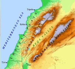
Lebanon's geography has a prominent influence on where civilizations formed and thrived. The two mountain ranges caused most of the population to settle on the coastal plain where there are many resources to benefit from in addition to the sea.
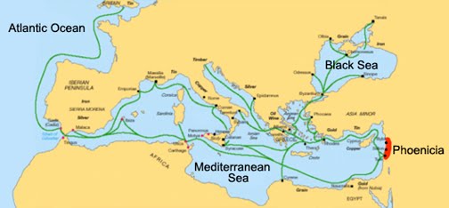
This is a map of the Phoenician trade routes and sailing ventures that took place in the 3rd century BCE. The Phoenicians had a strong interest in finding ports where their shipping and trading interests could be enhanced. Phoenicia was a Mediterranean nation.
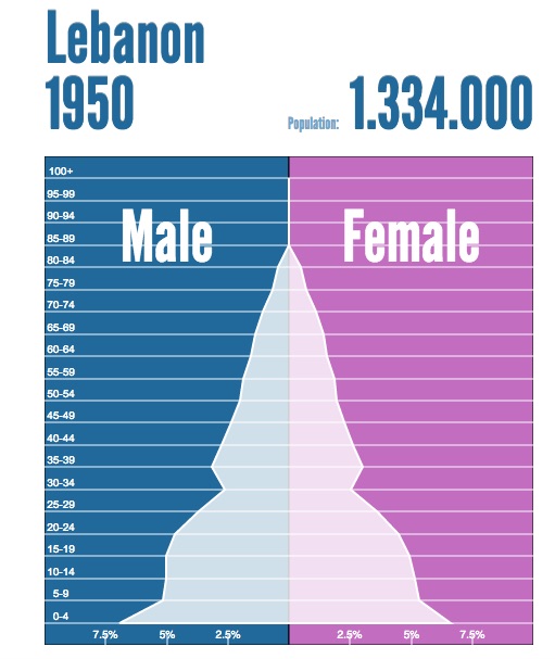
This population pyramid of Lebanon in 1950 shows the majority of the population to be in the pre-reproductive age. This is the sign of a developing country, for it's population is lately to double in size in the upcoming decades.
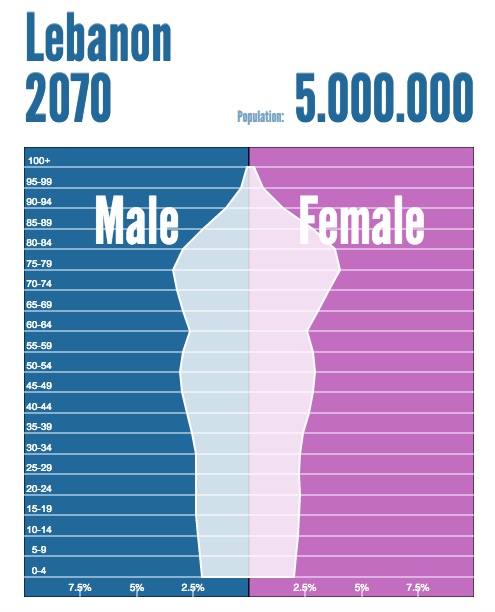
This population pyramid goes into Lebanon's future in the year 2070. The area of the population that is largest is in the post- reproductive group. In addition, the rest of the pyramid is fairly stable which is the sign of a stable population that might slightly decrease in total population as well.
|
